Enjoy fast, free delivery, exclusive deals, and award-winning movies & TV shows with Prime
Try Prime
and start saving today with fast, free delivery
Amazon Prime includes:
Fast, FREE Delivery is available to Prime members. To join, select "Try Amazon Prime and start saving today with Fast, FREE Delivery" below the Add to Cart button.
Amazon Prime members enjoy:- Cardmembers earn 5% Back at Amazon.com with a Prime Credit Card.
- Unlimited Free Two-Day Delivery
- Streaming of thousands of movies and TV shows with limited ads on Prime Video.
- A Kindle book to borrow for free each month - with no due dates
- Listen to over 2 million songs and hundreds of playlists
- Unlimited photo storage with anywhere access
Important: Your credit card will NOT be charged when you start your free trial or if you cancel during the trial period. If you're happy with Amazon Prime, do nothing. At the end of the free trial, your membership will automatically upgrade to a monthly membership.
Download the free Kindle app and start reading Kindle books instantly on your smartphone, tablet, or computer - no Kindle device required.
Read instantly on your browser with Kindle for Web.
Using your mobile phone camera - scan the code below and download the Kindle app.
Isle Royale National Park Map (National Geographic Trails Illustrated Map, 240) Map – Folded Map, January 1, 2019
Purchase options and add-ons
• Waterproof • Tear-Resistant • Topographic Map
A rugged and isolated island on Lake Superior, Isle Royale offers unparalleled opportunities for hiking, backpacking, boating, paddling, and scuba diving in solitude, far from the sights and sounds of civilization. National Geographic's Trails Illustrated map of Isle Royale National Park delivers unmatched detail and valuable information to assist you in your exploration of this remote wilderness. Created in partnership with local land management agencies, this expertly researched map features key areas of interest including Passage Island, Rock Harbor, Windigo, and many shipwreck sites.
Whether day hiking or backpacking to remote campsites, the map's clearly marked trails with mileage between intersections will help you choose the route that's right for you. The map base includes contour lines and elevations for summits and lakes, as well as soundings of Lake Superior. Boaters will appreciate the handy water mileage chart. Recreation features are clearly marked, including campgrounds, interpretive trails, lighthouses, lookout towers, ferry routes, docks, and seaplane anchorages. A variety of helpful information about camping, fishing, and boating in the region is included as well.
Every Trails Illustrated map is printed on "Backcountry Tough" waterproof, tear-resistant paper. A full UTM grid is printed on the map to aid with GPS navigation.
Other features found on this map include: Blake Point, Cumberland Point, Feldtmann Ridge, Isle Royale, Siskiwit Bay, Sugar Mountain.
- Map Scale = 1:50,000
- Sheet Size = 37.75" x 25.5"
- Folded Size = 4.25" x 9.25"
- Print length2 pages
- LanguageEnglish
- PublisherNational Geographic Maps
- Publication dateJanuary 1, 2019
- Dimensions4.1 x 0.3 x 8.9 inches
- ISBN-101566953677
- ISBN-13978-1566953672
Frequently bought together
Similar items that may deliver to you quickly
From the Publisher
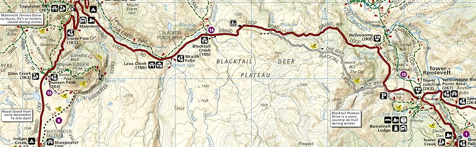
National Geographic Trail Maps – An essential tool for exploring America’s top National Parks
National Geographic’s line of Trails Illustrated maps includes detailed topographic trail maps for all of America’s top National Parks. Featuring updated and easy-to-read trail networks, important points of interest, and the key recreation information needed to make your next National Park visit an adventure.
National Geographic and the National Parks share a deep legacy dating back to the publication of an entire issue of National Geographic Magazine in 1916 titled 'Land of the Best'. That issue helped advocate for the creation of the National Park Service, later that year. Over the years, National Geographic has helped establish, preserve, or restore Sequoia, Katmai, Carlsbad Caverns, Shenandoah, Mesa Verde and Redwood National Parks. It has also publicized the parks through at least 500 books, articles, and maps, not to mention dozens of television documentaries.
Backcountry Tough
- Waterproof
- Tear-Resistant
- Nearly Indestructible
- Detailed Topography
- GPS Compatible With full UTM Grid
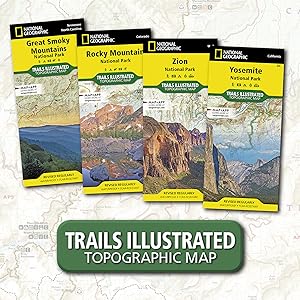
Great Smoky Mountains National Park | Zion National Park | Rocky Mountain National Park | Yosemite National Park | Yellowstone National Park | |
---|---|---|---|---|---|
Customer Reviews |
4.8 out of 5 stars
800
|
4.8 out of 5 stars
527
|
4.8 out of 5 stars
704
|
4.7 out of 5 stars
453
|
4.7 out of 5 stars
776
|
Price | $14.94$14.94 | $11.10$11.10 | $13.81$13.81 | $11.49$11.49 | $13.46$13.46 |
Yearly Visitors | 11.3 million | 4.5 million | 4.4 million | 4.3 million | 4.1 million |
Date Established | 1934 | 1919 | 1915 | 1890 | 1872 |
Miles of Trails | 820 miles | 88 miles | 431 miles | 782 miles | 1,021 miles |
State | North Carolina, Tennessee | Utah | Colorado | California | Wyoming, Montana, Idaho |
Editorial Reviews
About the Author
Product details
- Publisher : National Geographic Maps; 2019th edition (January 1, 2019)
- Language : English
- Map : 2 pages
- ISBN-10 : 1566953677
- ISBN-13 : 978-1566953672
- Item Weight : 3.2 ounces
- Dimensions : 4.1 x 0.3 x 8.9 inches
- Best Sellers Rank: #30,169 in Books (See Top 100 in Books)
- #13 in Midwest US Travel Guides (Books)
- #47 in Hiking & Camping Excursion Guides (Books)
- #60 in Maps (Books)
- Customer Reviews:
Important information
Legal Disclaimer
NA
Customer reviews
Customer Reviews, including Product Star Ratings help customers to learn more about the product and decide whether it is the right product for them.
To calculate the overall star rating and percentage breakdown by star, we don’t use a simple average. Instead, our system considers things like how recent a review is and if the reviewer bought the item on Amazon. It also analyzed reviews to verify trustworthiness.
Learn more how customers reviews work on AmazonReviews with images
-
Top reviews
Top reviews from the United States
There was a problem filtering reviews right now. Please try again later.
I have bought two of these and taken them across the island, and both weathered the trip well (no tears or stains).
The distance indications seem pretty accurate, though I didn't have an odometer to test them.
Overall, it's a map. Would recommend.
The terrain features are accurate in all the areas I visited in 2014. It's a BIG map but I like that because it allows a high degree of fidelity, especially handy when you decide to (or are forced) off trail. The map cuts very well, if you want to trim it down to size for your specific trip . I don't hike on water so if I'm staying on one end of the island I'll cut off all the water around the island till the map is as small as possible (with room for navigation errors).
The one improvement I wish they'd make is adding a trail distance chart like they have with the water distance chart to make on the fly planning easier.
This is a great map for traveling to a great segment of isolated wilderness.